
This article was originally published in Afar.
Sandwiched between Jalisco and Michoacán on the Pacific coast, Colima is one of the smallest states in Mexico. The semicircle-shaped region is about the size of Delaware and boasts 100 miles of coastline. Colima’s best-known seaside town, Manzanillo, has grown this past decade alongside its glitzy northern neighbor Puerta Vallarta, albeit at a much slower pace. But inland, the region’s lush, volcanic landscape is, by comparison, virtually unknown—though it probably won’t be that way for long.
Part of Colima’s appeal is that it’s so compact—the city, the mountains, the villages, and the beach are all within an hour’s radius. The state’s capital city, also named Colima, sits in the heart of the countryside. But the city is merely an urban speck on the raw and rugged landscape. Drive just a few miles and you’re among fields punctuated by two massive volcanoes rising above historic villages. Drive 35 miles, and you’re at one of the region’s best surf spots.
Colima is serviced by an airport that receives, at most, five flights a day (all domestic). A trip to this worth-the-effort place thrusts visitors into a diverse region on the rise that has yet to be discovered by the masses. But the state saw 1 million visitors in 2017, and with cruise ship travel increasing to Manzanillo in the north—it welcomed 34,000 cruise ship passengers in 2017, up from 6,000 in 2014—there’s reason to believe more growth is on the way. Come along as we explore more of what Colima has to offer.
Do
Sean Farley, World Champion Kitesurfer and owner of the adventure tour company Elevate in Colima, describes his hometown as the “poor man’s Hawaii.” Of course, Colima is not an island—nor could one confuse Mexican and Polynesian cultures—but Farley makes a good point: Like Hawaii, the Mexican state boasts active volcanoes, tropical jungles, a vibrant tradition of art and culture, an internationally known surf break, and an abundant coastline that offers plenty of fishing and whale watching.
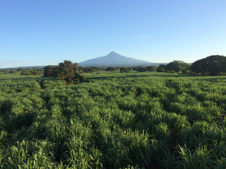
The majestic, coned top of the Colima Volcano rises approximately 13,000 feet above a sweeping agricultural region of sugarcane and coffee fields. Just behind it sits the taller Nevado de Colima, named for the snowy top. Spot pumas and jaguars as you hike the forests and volcanic terrain on the trails of El Parque Nacional Nevado de Colima, or admire it from above on a balloon ride with Elevate. The gray-stone ghost town of La Yerbabuena with its overground central square is just a few miles from the crater. Originally located further up the volcano, it was destroyed (but safety evacuated) during the 2005 eruption. The relocated town was evacuated again during an eruption in 2016. Although lava never reached the town, most residents never returned, and it remains fully intact and safe to visit today.
